.png)
One thing Daniel Burnham didn’t shy away from was criticism. He knew that Chicago had too much potential that was withering away. Before he even sat down to write the “Streets” section of his 1909 plan, Chicago’s City Council had spent decades trying
One thing Daniel Burnham didn’t shy away from was criticism. He knew that Chicago had too much potential that was withering away. Before he even sat down to write the “Streets” section of his 1909 plan, Chicago’s City Council had spent decades trying to rename, renumber, and reimagine the city streets.
After the major annexations of 1889, Chicago was tangled in the competing rules and systems of the townships it had absorbed. More than a decade earlier, the annexation of Hyde Park/Lake Township had already forced a major renumbering effort in 1879. This was an early sign of the challenges that would only grow as the city expanded.
The system (or lack thereof) that was in place made no sense… I tried…
Streets north and south of 12th street (now Roosevelt) began with 1200.
Streets north and south west of the River (but crossed to the east) used the new numbering system
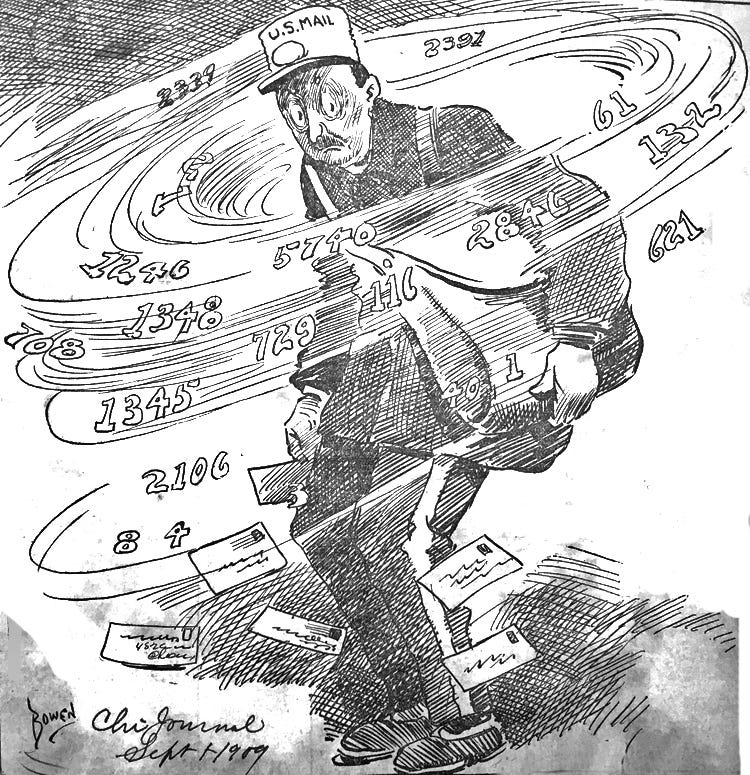
By 1891 there were three Grand Divisions; North, South, and West. The consensus was that Chicago’s streets were causing major issues as the city expanded. The Standard Guide to Chicago for the Year 1891 gave a great example of what the confusion was; one part of the city might have a Lake Street, while another had a Lake Avenue. You could ride down Park Avenue on the West Side, only to encounter an entirely different S. Park Avenue miles away on the South Side.
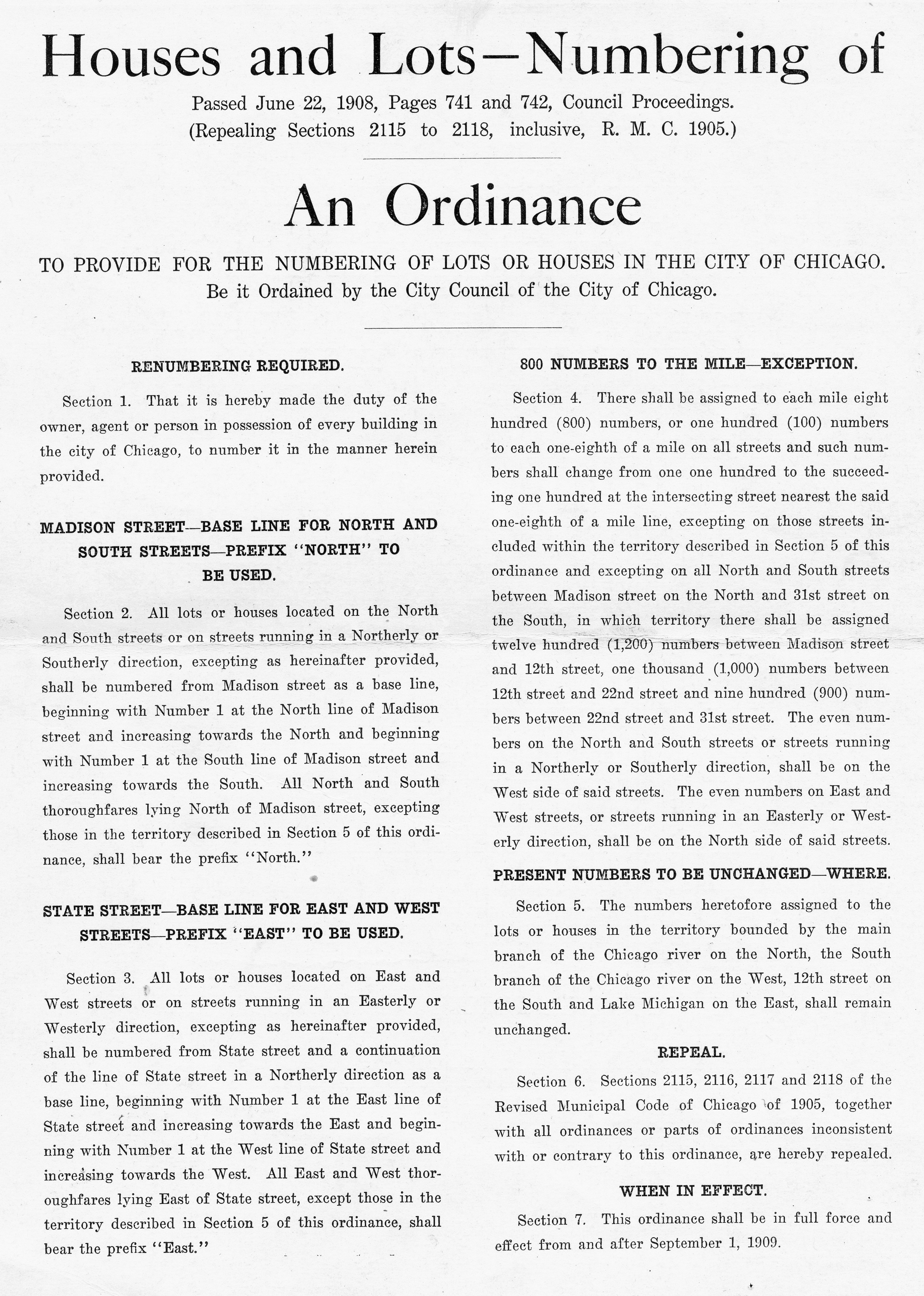
In 1901 the Chicago Tribune reported on a City Council meeting that highlighted the problem; the numbering system was using the Chicago River and Lake Michigan as the base line. This was obviously the root cause considering that neither ran in a straight line. That same year, June of 1901, Edward P. Brennan suggested a solution; a new baseline, State & Maddison. This was revolutionary!
“ The base lines are State street north and south and Madison street, east and west. Their function is the center from which all distances are measured. There is no use disturbing the central downtown district, as the commercial interests would be all up in arms against a change. To leave the commercial quarter untouched, however, would not conflict with the application of the scheme to the rest of the city. Below Twelfth street and beyond the river’s arms the reform could be easily put into practice.”
The City Council continued to argue about the best way to renumber and rename streets. The cost of $1-$2 per house was causing major delays. Aldermen across the city made suggestions for their wards that the Chicago Tribune labelled as “ schemes that are as plain as the Chinese language suggested to simplify Chicago’s street number”.
In 1908 an ordinance was passed. State and Madison were now the center of the grid. The ordinance went through a few more amendments but was solidified and went into effect in 1909. It faced another round of amendments in 1910, and by 1911 the ordinance included the Loop. Enter Daniel Burnham…
Burnham’s plan was concerned with the general look of the city. The streets needed to be wider, allowing more space for leisure, there needed to be designated paths for different forms of transportation. Streets in the Loop needed to be widened and spread further North and South, East and West. His focus was on providing fresh air, sunlight, and access to green spaces.
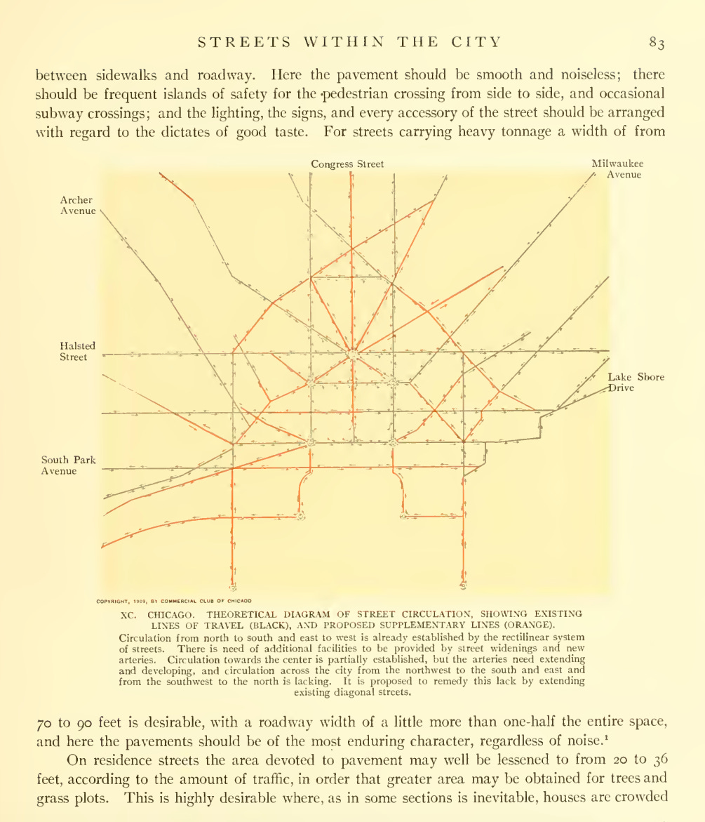
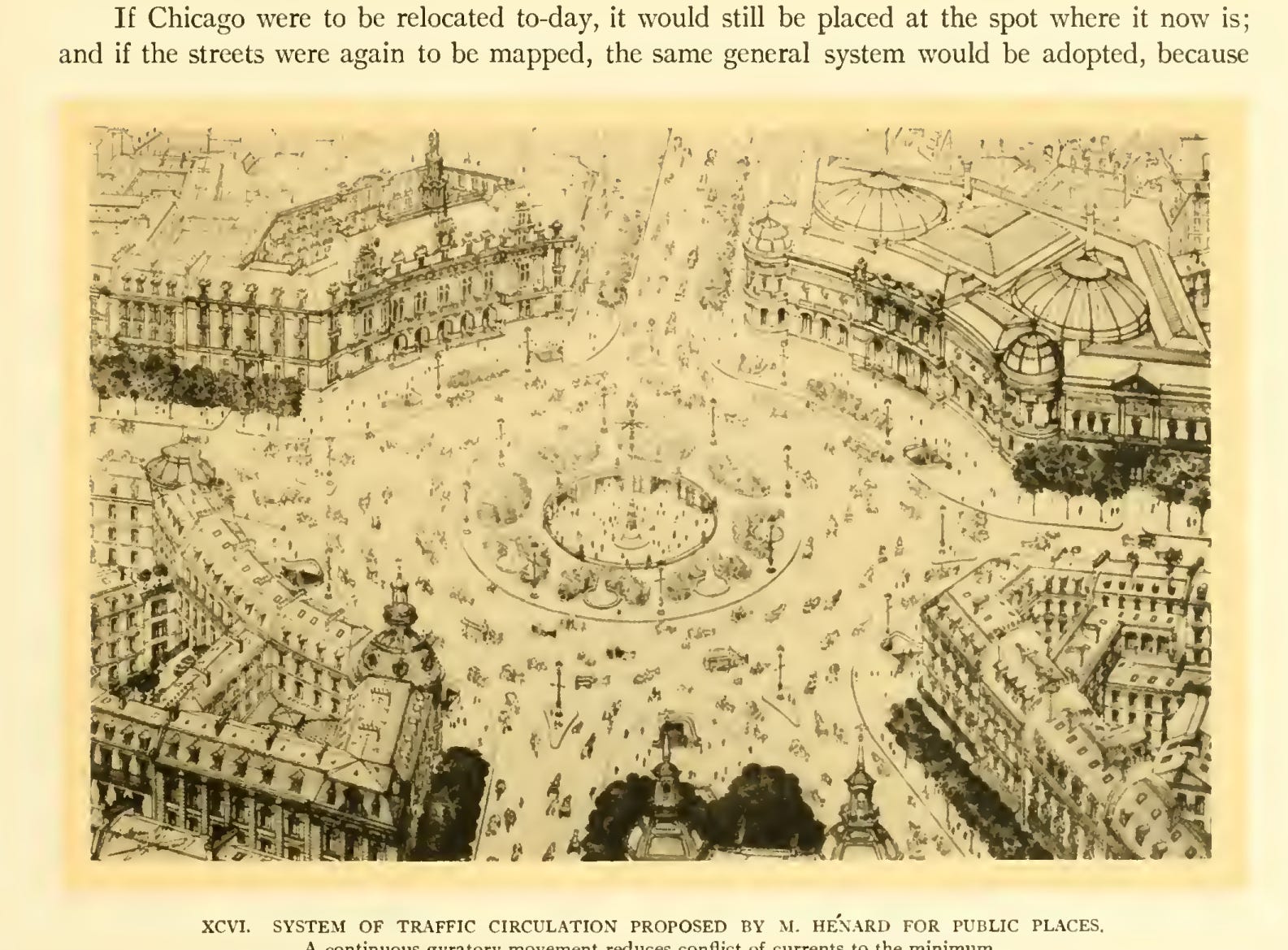
The Plan showed the city as a mix of a grid system and a radial concept where there was a harmonious flow between streets, parks, and pedestrian parkways. Burnham imagined that a retail district in the Loop would be made up of streets that ran 80-100 feet wide, divided equally between sidewalk and roadway. The grid would optimize the flow of traffic; moving southwest to northeast and southeast to northwest. Diagonal streets would extend, Milwaukee Ave as an example, to reach other major towns.
“In the case of open spaces, effectiveness of architectural design is to be obtained only by a large unity in the entire composition. The harmonious treatment of the buildings facing the circle opposite the railway station in Rome and on the Place Vendôme in Paris, and the plan adopted for the plaza in front of the Union Station at Washington, all prove that an imposing effect can be produced by a unified and grandly simple design.”
Burnham criticized Chicago streets and for good reason. Not only was the numbering system confusing, and the names were inconsistent, the city also had trains running through neighborhoods, freight traffic and pedestrian traffic on the same parts of the streets, and limited open spaces.Chicago’s street system didn’t just need fixing, it needed a philosophy. What Burnham recognized, and what decades of failed renumbering attempts had already proven, was that piecemeal solutions couldn’t untangle a city that had grown without a shared vision.
By the time State and Madison were established as the center, the city had finally agreed on a framework. But Burnham pushed beyond function. He saw streets not just as routes to move people and goods, but as the connection of civic life for spaces that could inspire, organize, and elevate the everyday experience of the city. Order, in his view, wasn’t only about numbers and names; it was about beauty, balance, and intention.
Streetwise Chicago: A History of Chicago Street Names - Don Hayner and Tom McNamee
City of the Century: The Epic of Chicago and the Making of America is a 1996 nonfiction history book by American historian Donald L. Miller. It chronicles Chicago’s rise from a frontier settlement to a modern metropolis and cultural powerhouse, portraying the city as a microcosm of industrial-age America.
The Blues Brothers
Burnham Episode - Audio
Brendan Fernandes’ ‘In The Round’ - Score for The Murphy Auditorium

Chicago Street Re-numbering - Chicagology
Street Re-numbering - The Chicago Directory Company
Plan of Chicago - 1909 plan by Daniel Burnham
.png)
%20(1).png)